Here is an example, well-defined coastal locality, Pipe Clay Lagoon in south-east Tasmania, Australia, from the ground (top), and with a location shot generated via the NASA "World Wind" application based on Landsat TM data and a digital elevation model (below). How can we establish a relevant georeference for this location (preferably without having to go down there with a hand-held GPS)?
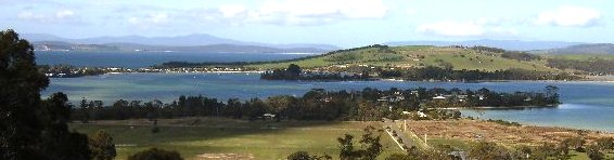
Pipe Clay Lagoon, SE Tasmania, Australia, looking east (photo: Tony Rees)
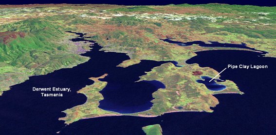
Location shot, generated via NASA "World Wind" application (north is at top; labels are a manual addition)
The image accessible via this thumbnail shows a portion of the relevant 1:50 000 (coastal) navigational chart, which permits the locality name "Pipe Clay Lagoon" to be associated with a recognisable coastal feature:
 (click to enlarge)
First, using a couple of on-line gazetteers, we can get the following results by querying on the locality name:
- Gazetteer of Australia, via Geoscience Australia website: Latitude 42° 58' S, longitude 147° 31' E (decimal degrees: -42.967, 147.523) [website]
- Alexandria Digital Library gazetteer: Latitude -42.9667, longitude 147.5333 (degrees/min 42° 58' S, longitude 147° 32' E ) [website]
- Using the "show cursor location" feature of NASA World Wind, we can obtain a reading for the approximate centre of Latitude -42.9735260009766, longitude 147.52424621582 (degrees/min 42° 58.4' S, longitude 147° 31.5' E ) [screenshot]
- Using the "view gridlines" feature of Google Earth, it can be seen that the limits of Pipe Clay Lagoon are approximately N limit 42° 57.15' S, S limit 42° 59.1' S, W limit 147° 30.6' E, E limit 147° 32.4' E, thus a value for the centre of 42° 58.1' S, 147° 31.5' E (decimal: -42.968, 147.525) is reasonable [screenshot].
Conclusions
- Available online gazetteers can provide rapid automated georeferencing, to a precision of around 1 minute of arc (around 1.8 km N-S, 1.3 km E-W), provided that (1) the locality name is listed unambiguously in the gazetteer, (2) the point which the gazetteer uses for its georeference coincides with the actual desired "marine" feature, and (3) the gazetteer itself contains no inaccuracies.
- Manual georeferencing using on-line digitised maps can provide improved precision (e.g. to 0.1 minute of arc, i.e. a x10 improvement) and accuracy (in terms of targeting the exact desired feature), and can also allow encoding of the feature extent if desired - for example, as a radius of uncertainty, or a bounding box. However, this method cannot be automated in the first instance. It also requires access to a map which allows the feature name to be associated with its actual extent (since small-scale local features may not be named on the current available on-line digitised maps, other available maps may need to be consulted).
- Which method is chosen depends therefore on the accuracy and precision desired, the number of localities that require georeferencing, and available resources (person time). An "ideal" solution in some cases (e.g. with a limited number of features to georeference) could be to manually georeference all the features once, then store the resulting values in a table or database for subsequent automated lookup - in other words, create a custom gazetteer of known precision, accuracy and completeness, tailored to the data at hand.
![]() This site is hosted by the CSIRO National Collections and Marine Infrastructure Information and Data Centre, Australia.
Please advise any problems with this website to the OBISAU Node Manager.
View Privacy Statement
This site is hosted by the CSIRO National Collections and Marine Infrastructure Information and Data Centre, Australia.
Please advise any problems with this website to the OBISAU Node Manager.
View Privacy Statement